Welcome to our store!

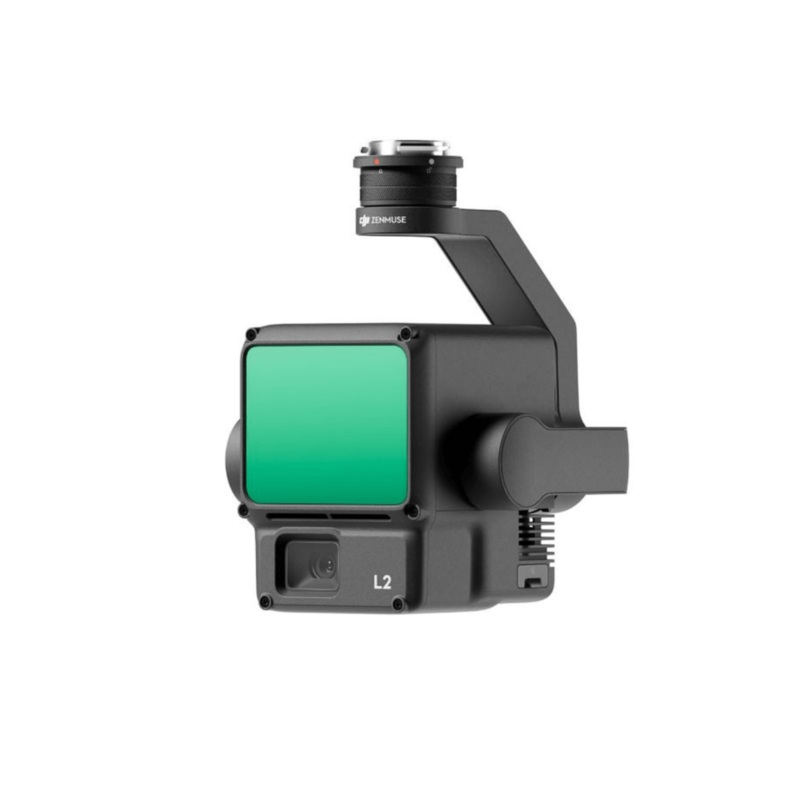
High Precision |Exceptional EfficiencySuperior Penetration250m/450m Detection Range5 ReturnsTurnkey SolutionPoint Cloud LiveViewDJI Care 1yr Warranty - BasicOne-Click Processing on DJI TerraWhat's Included(1) Zenmuse L2(1) microSD Card (128GB)(1) Lens Cap(
(1) Zenmuse L2
(1) microSD Card (128GB)
(1) Lens Cap
(1) Storage Case
(1) Lens Cleaning Cloth
Introducing the Revolutionary DJI Zenmuse L2 LiDAR Payload, specially engineered to revolutionize your aerial surveying and mapping capabilities. Designed for seamless integration with the DJI Matrice 350 and 300 series, this state-of-the-art LiDAR solution delivers exceptional precision and efficiency. The Zenmuse L2 excels in penetrating dense canopies and intricate structures, providing you with the critical data you need.
With a remarkable detection range spanning from 250 meters to 450 meters and the capacity to capture up to five data points from a single pulse, this payload offers the accuracy and coverage demanded by your surveying projects.
Effortlessly streamline your data acquisition process with the DJI Zenmuse L2a turnkey solution that simplifies LiDAR scanning workflows. The real-time Point Cloud LiveView ensures you capture accurate data on the fly, optimizing decision-making. The one-click processing feature, seamlessly integrated with DJI Terra, simplifies data management and analysis, allowing you to focus on critical project insights rather than time-consuming data processing.
Elevate your surveying and mapping capabilities to new heights with the DJI Zenmuse L2 LiDAR payloadprecision, efficiency, and user-friendliness have never been this accessible.
An All-Inclusive LiDAR Solution
With its robust hardware, the L2 allows for precise scanning of intricate subjects over extended ranges, facilitating rapid point cloud acquisition. During operations, users can preview, playback, and process point cloud models on-site, with Task Quality Reports generated by DJI Terra, providing a straightforward, comprehensive solution to enhance overall efficiency. This empowers users to achieve high-precision point cloud results with a simplified post-processing approach.
By combining GNSS and a high-accuracy self-developed IMU, this solution achieves 4cm vertical accuracy and 5cmhorizontal accuracy.
Its ready for work as soon as its powered on and can collect both geospatial and RGB data from a 2.5km2 area in a single flight.
In conjunction with Matrice 350 RTK and DJI Terra, L2 offers a turnkey solution that is simple to use, lowering the operational threshold.
L2 can detect from 250 meters at 10% reflectivity and 100 klx, and up to 450 meters at 50% reflectivity and 0 klx. The typical operational altitude now extends up to 120 meters, notably enhancing operational safety and efficiency.
With a reduced spot size of 412 cm @100m, only a fifth of that of L1, L2 not only detects smaller objects with more details, but can also penetrate denser vegetation, generating more accurate digital elevation models (DEM).
In densely vegetated areas, L2 can capture more ground points beneath the foliage.
In both single and multiple return modes, L2 can reach a max point cloud emission rate of 240,000 points per second, allowing the acquisition of more point cloud data in a given time frame
L2 supports two scanning modes, offering flexibility for users based on their task demands. In repetitive scanning mode, L2’s LiDAR can achieve more uniform and accurate point clouds while meeting high-precision mapping requirements. In non-repetitive scanning mode, it offers deeper penetration for more structural information, making it suitable for power line inspection, forestry surveying, and other surveys.
The frame-based design results in an effective point cloud data rate of up to 100%. Together with a three-axis gimbal, it brings more possibilities to surveying scenarios.
The high-accuracy self-developed IMU system, combined with the drones RTK positioning system for data fusion during post-processing, gives L2 access to highly accurate absolute position, speed, and attitude information. In addition, the IMU systems enhanced environmental adaptability improves the operational reliability and precision of L2.
Yaw Accuracy
Real-time: 0.2, post-processing: 0.05
Pitch/Roll Accuracy
Real-time 0.05, post-processing 0.025
The performance of the IMU system has been significantly enhanced, and it is ready for use the moment it’s powered on. And, the accompanying drone is ready to begin tasks immediately once the RTK is in FIX status, delivering an optimized in-the-field experience.
Pixel size has been enlarged to 3.3 m, and effective pixels now reach 20 MP, resulting in a significant improvement in overall imaging, as well as more enriched true-color point cloud details. The minimum photo interval has been reduced to 0.7 seconds. The mapping camera has a shutter count of up to 200,000 times, further reducing operational costs. When point cloud collection is not needed, the RGB camera can still take photos and videos, or collect images for visiblelight mapping

Reviews
There are no reviews yet.