Welcome to our store!

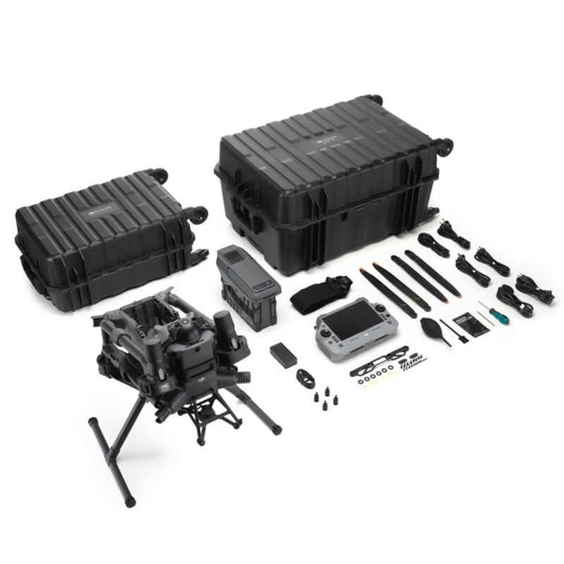
DJI Matrice 400 engineered for excellence, designed for unmatched versatility. DJIs newest enterprise flagship stretches flight endurance, payload flexibility, and situational awareness further than any Matrice to date. With a class-leading 59-minute forwa
DJI Matrice 400 engineered for excellence, designed for unmatched versatility. DJIs newest enterprise flagship stretches flight endurance, payload flexibility, and situational awareness further than any Matrice to date. With a class-leading 59-minute forward-flight time, a 13.2 lb / 6 kg maximum payload, and a triple-layer obstacle-sensing suite that pairs rotating LiDAR with mmWave radar and full-color low-light vision, the M400 empowers power-grid engineers, search-and-rescue crews, surveyors, and AEC professionals to cover more ground in fewer flightsday or night, rain or shine.
DJI Matrice 400 – 6kg (13lbs) Payload Capacity
Four E-Port V2 interfaces, dual downward gimbals, and a third underslung gimbal connector let the M400 fly up to seven simultaneous payloads. Seamlessly switch between single – or dual-gimbal set-ups to suit the assignment.
*Payloads sold separately.
Estimate the Matrice 400s flight time based on your payload configuration.
Rated IP55, the Matrice 400 performs dependably in harsh environments, shrugging off heavy dust and rain. Designed for temperature extremes, it delivers consistent performance from 20 C to 50 C (4 F to 122 F), ensuring reliable results in both frigid and scorching conditions.
An integrated rotating LiDAR + mmWave radar + full-color low-light vision system detects obstacles as small as 0.85 in / 21.6 mm conductors at speeds up to 56 mpheven in fog, rain, or total darkness. Six fisheye cameras switch to black-and-white below 12 lux for enhanced contrast, while GNSS + Vision Fusion maintains precise positioning in GPS-denied canyons, under bridges, and alongside glass-curtain facades.
Rotating LiDAR, radar, and fisheye vision fuse with dual-band GNSS to create centimeter-class positional accuracyeven when primary satellites fade. Four full-color fisheye sensors feed Full-Color Vision Assist, overlaying a pilot-eye view on the controller to reveal blind-spot hazards during complex maneuvers.
Paired with the H30 Series, onboard AI auto-labels vehicles, vessels, and people across visible and thermal feeds, pushing real-time metadata to FlightHub 2 for team-wide situational awareness.
Maintains constant AGL in any horizontal directionperfect for slope mapping, forest SAR, or uniform-GSD photogrammetry.
Pattern-recognition landing detects deck markers and lands safely on vessels moving 10 knots (11.5 mph). Critical for coastal patrol and offshore turbine inspection.
The M400 natively supports DJI Pilot 2 quick-task templates, slope and geometric route planners in FlightHub 2, and power-line follow missions when paired with the Zenmuse L2 LiDAR. Onboard compute continuously analyzes LiDAR returns to auto-sidestep crossing conductors during energized-line patrols.

Reviews
There are no reviews yet.