Welcome to our store!

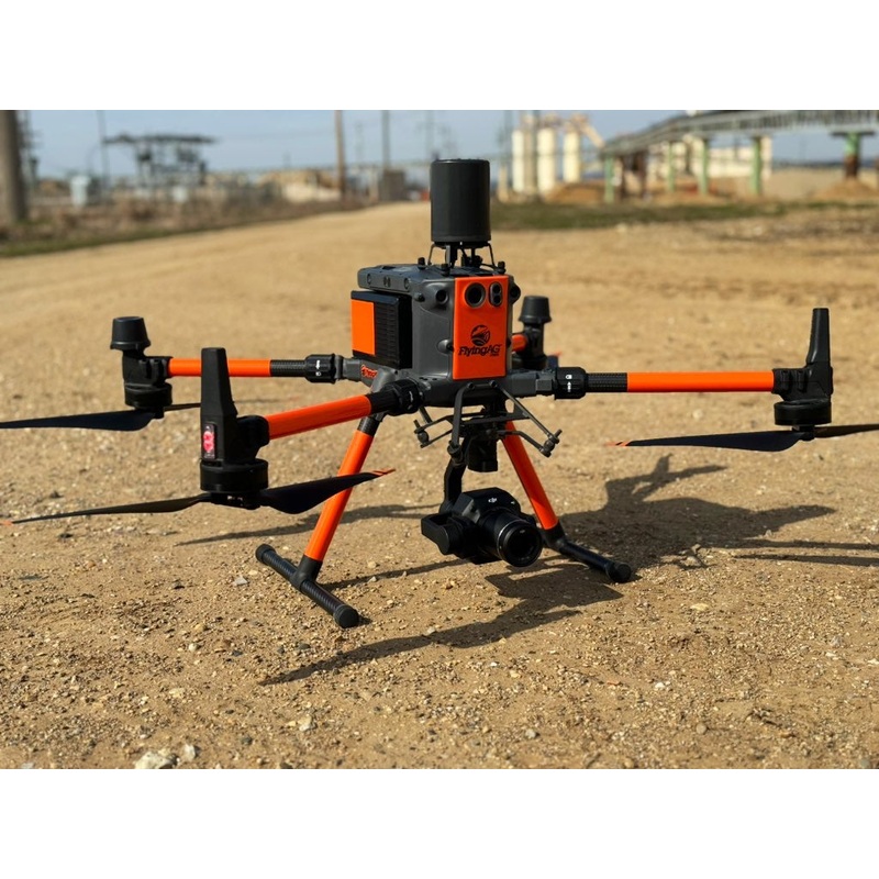
Our M350 RTK Pro Kit is the flagship drone for the industry. This cutting-edge ag drone platform introduces a brand-new video transmission system and control interface, an enhanced battery system for increased efficiency, and a broader array of safety feat
Our M350 RTK Pro Kit is the flagship drone for the industry. This cutting-edge ag drone platform introduces a brand-new video transmission system and control interface, an enhanced battery system for increased efficiency, and a broader array of safety features. Additionally, it boasts robust payload capacity and expandable capabilities. This thermal mapping drone stands fully equipped to infuse innovation and strength into any aerial mission.
Our custom M350 RTK Pro Kit includes:
The M350 RTK Profeatures the DJI O3 Enterprise Transmission system, providing the capability to handle triple-channel 1080p HD live streaming, [5] and offering an impressive maximum transmission range of 12.4 miles. [6] Both the thermal mapping drone and the remote controller are equipped with a sophisticated four-antenna transceiver system. This system intelligently selects the best two antennas for transmitting signals while simultaneously receiving signals through all four antennas. The smart design of the Matrice 350 RTK thermal mapping drone greatly enhances anti-interference capabilities and optimizes the stability of data transmission.
DJI RC Plus Controller featuresa 7-inch high-brightness display, the DJI RC Plus introduces Dual Operator Mode and includes a standard WB37 external battery, delivering a remarkable operational duration of up to six hours to cater to diverse mission requirements.
With its IP54 rating, [2] DJI RC Plus is both dustproof and waterproof, ensuring dependable performance in adverse weather conditions. It can operate within a temperature range of -4F to 122F, making it suitable for around-the-clock use in extremely hot or cold environments.
The remote controller for this thermal mapping drone is equipped with numerous buttons and dials, strategically positioned on the front, back, and top for swift operation. These button functionalities can be tailored to align with user preferences, providing an intuitive and adaptable user experience.
The DJI Pilot 2 application has undergone enhanced optimization, presenting mission types and flight statuses with greater clarity. This streamlined control over both the drone and payloads promotes increased operational efficiency.
The Matrice 350 RTK comes furnished with an innovative TB65 dual-battery system. This system not only supports hot-swapping batteries but also enables multiple flights without requiring a power-off cycle. With the capability to endure up to 400 charging cycles, [3] it significantly diminishes the cost associated with each flight.
The new BS65 Intelligent Battery Station provides a one-stop solution for battery charging, storage, and transport.
In Storage Mode, charge the battery to 50%, which is good for long-term storage. In Ready-to-Fly Mode, quickly charge multiple battery sets to 90% to start operation at any time and extend the battery life.
When the battery station is connected to DJI RC Plus, the DJI Pilot 2 app will display the battery status and health information. In addition, you can set the number of self-discharge days, update the firmware, export logs, and access other quick operations with one tap.
The battery station is designed with 360-movement wheels for more convenient transportation and transitions.
Matrice 350 RTK supports Waypoint, Mapping, Oblique, and Linear Flight missions which makes it the perfect ag drone for surveying. You can use Terrain Follow [12] or Smart Oblique [13]for efficient data collection. Together with DJI Terra, you can quickly obtain HD 2D and 3D digital results, enabling high-precision and high-efficiency mapping operations.
With functions like the high-precision PinPoint and cloud-based real-time mapping, [14] the Matrice 350 RTK can link the air, ground, and cloud together. After the thermal mapping drone aircraft completes image collection, DJI FlightHub 2 can quickly model the operation site and transmit command information to the aircraft and ground operators. Both the remote controller and FlightHub 2 support point, line, surface drawing, and real-time uploading, and can cooperate with the aircraft to livestream the real-time operation view, breaking through communication barriers for air-to-ground collaborative operation.
Through Live Mission Recording, the Matrice 350 RTK can generate and store flight route files that can be used at any time to realize automated operation and make repetitive inspection no longer time-consuming or effort-consuming. When using AI Spot-Check, [15]the Matrice 350 RTK supports automatic framing and manual adjustment of subjects to improve the accuracy of repeated shooting and the quality of inspection operation.
The CSM Radar can be mounted on top of the drone to further ensure flight safety. The effective detection range can reach 30 m. [10] The radar can accurately detect subtle obstacles upward or within the horizontal 360 range to avoid them in time. [9]
The Matrice 350 RTK supports a single downward gimbal, dual downward gimbals, [11] and a single upward gimbal, [11] and can carry three payloads simultaneously. This ag drone for surveying also has an E-Port open interface and a max payload capacity of 2.7 kg, meeting the needs of different operation scenarios like public safety, inspection, and mapping.
Zenmuse H20:The triple-sensor system of zoom camera, wide camera, and laser rangefinder works together, supplemented by advanced intelligent algorithms, to deliver outstanding sensing and imaging performance. (20 MP Sensor w/ 23x Optical Zoom Camera,12 MP Wide Camera &1200 meter LRF – laser range finder).
Zenmuse H20T( Daylight Thermal): Capture everything. quad-sensor model with a wide-angle camera, a zoom camera, a laser rangefinder, and a radiometric thermal camera.An integrated laser rangefinder (LRF) measures the distance to an object at up to 1200 m away. (20 MP Sensor w/ 23x Optical Zoom Camera,12 MP Wide Camera,1200 meter LRF – laser range finder, 640×512 px Radiometric Thermal Camera).
Zenmuse H20N (Night Thermal): Integrates starlight sensors into its 20x optical zoom and night vision wide-angle cameras. Pair this with dual zoom thermal cameras (2x & 8x) and a 1200 meter laser rangefinder, and you have a versatile thermal mapping drone hybrid that rises to the occasion during night operations.
Zenmuse P1: Integrates a full-frame sensor with interchangeable fixed-focus lenses on a 3-axis stabilized gimbal. Designed for photogrammetry flight missions, it takes efficiency and accuracy to a whole new level.
Zenmuse L2: lntegrates a Livox Lidar module, a high-accuracy IMU, and a mapping camera. When used with the flight platform, it forms a complete solution that gives you real-time 3D data throughout the day, efficiently capturing the details of complex structures and delivering highly accurate reconstructed models.
1. Measured with Matrice 350 RTK flying at approximately 8 m/s without payloads in a windless environment until the battery level reached 0%. Data is for reference only. Please pay attention to reminders in the app for the actual usage time.
2. Measured in a controlled environment. The IP rating is not permanently effective and may decrease due to product wear and tear.
3. Up to 400 cycles if the accumulative duration of battery level 90% is less than 120 days within 12 months.
4. Measured with the 2112 High-Altitude Low-Noise Propellers and the takeoff weight 7.2 kg.
5. Dual Operator Mode required.
6. Measured with FCC compliance in an unobstructed environment with low interference at a flight altitude of approximately 120 m. Data is for reference only. During your flight, please pay attention to reminders in the app.
7. There are certain blind areas of visual sensing and infrared sensing. Positioning and obstacle-sensing performance may be affected by the flight environment and obstacle characteristics. Please fly with caution.
8. Sold separately.
9. Please enable the radar obstacle avoidance function in the DJI Pilot 2 app and set the aircraft safety distance (> 2.5 m is recommended), and the flight speed should be < 10 m/s.
10. Measured when the radar reflection cross-sectional area of the detection target is 0.4 m. The effective detection range may vary with the size and material of the obstacle.
11. Gimbal connector is sold separately.
12. This function requires the remote controller to connect to the Internet and download DEM files.
13. This function requires Zenmuse P1.
14. DJI FlightHub 2 required.
15. This function requires the Zenmuse H20 Series payloads.
16. The accessories in this section can also be used with the Matrice 300 RTK.
17. Measured with CE compliance.
18. The aircraft comes with E-Port, while SkyPort and X-Port components are sold separately.
Reviews
There are no reviews yet.