Welcome to our store!

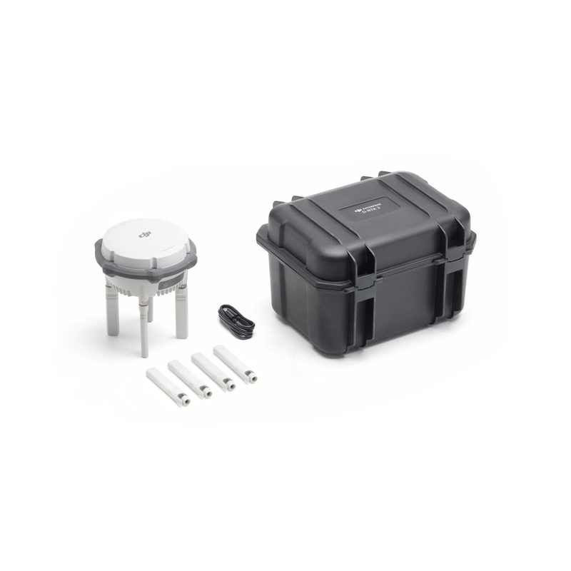
The game-changing D-RTK 3 Multifunctional Station by DJI has arrived, bringing groundbreaking precision and versatility to drone operations. Whether you're seeking high-precision positioning for surveying and mapping or need a reliable image transmission r
The game-changing D-RTK 3 Multifunctional Station by DJI has arrived, bringing groundbreaking precision and versatility to drone operations. Whether you’re seeking high-precision positioning for surveying and mapping or need a reliable image transmission relay for inspection or search and rescue operations, the D-RTK 3 offers unparalleled performance and adaptability.
The D-RTK 3 Multifunctional Station is designed to meet the needs of enterprise users with its advanced components and features. It boasts high-performance air dielectric antennas with millimeter-level phase center accuracy, ensuring exceptional precision. The station supports data from five global navigation systems across 19 frequency points, offering extensive satellite compatibility. Its flexible transmission capabilities include Broadcast Mode, Relay Mode, and Rover Mode for adaptable operation. Additionally, it integrates seamlessly with DJI Enterprise drones, DJI Terra, and the DJI Enterprise app, making it ideal for mapping and precision tasks. Compatible with drone series such as the Matrice 4 Series, Matrice 300 RTK, and Mavic 3 Enterprise, the D-RTK 3 delivers unmatched versatility for enterprise operations.
Precision is at the core of the D-RTK 3s performance. With its advanced filtering antenna design, this system delivers reliable centimeter-level accuracy, even in challenging environments. Whether operating in urban areas with significant obstructions or remote locations with limited connectivity, the D-RTK 3 ensures exceptional precision. It supports standalone Precise Point Positioning (PPP), providing decimeter-level accuracy even in areas with weak internet connectivity. Additionally, it effectively manages multi-path interference while tracking low-elevation satellites. This makes it an ideal solution for high-precision applications like mapping, inspection, and 3D modeling.
The D-RTK 3s Broadcast Mode allows multiple devices to connect simultaneously without additional configuration, making it ideal for businesses managing large drone fleets. With O4 Enterprise video transmission and directional antennas, it ensures stable video transmissions over distances of up to 15 km. This technology enables seamless multi-drone connectivity, providing precise positioning for all units. It is particularly useful for agriculture businesses coordinating drone fleets for crop spraying, as well as enterprises conducting multi-drone surveys, inspections, or emergency response operations.
Relay Mode can support the new Matrice 4 Series. When deployed at an elevated location, it can potentially extend the operational range when there are obstacles between the RC and the aircraft. The system monitors obstructions in real-time and calculates optimal positions to ensure clear signals between drones, controllers, and relay stations. This feature is particularly useful for urban operations, where tall structures can disrupt signals, and for surveying remote landscapes such as mountainous terrains or deep valleys.
Flexibility is a key advantage of the D-RTK 3, which can also function as a rover station for precise control point coordinates collection during drone mapping projects. It works seamlessly with DJI Enterprise APP to efficiently create high-precision maps and simplifies workflows with tilt compensation, allowing measurements without needing the rover pole to be perfectly vertical. Additionally, it enables one-click export of ground control point data for processing in DJI Terra. Surveyors and cartographers will appreciate how Rover Mode enhances operational accuracy while significantly reducing setup time.
The D-RTK 3’s integration with DJI Terra streamlines aerial surveying, making it faster and more efficient than ever. Data collected by the D-RTK 3 can be easily imported into DJI Terra for post-processing, enabling the quick generation of maps and 3D models. It supports both PPK (Post-Processed Kinematics) and RTK (Real-Time Kinematics) workflows, ensuring compatibility with various surveying needs. Additionally, it allows projection coordinate conversion, making it simple to output planar coordinates in mainstream formats. This seamless collaboration provides surveyors with a comprehensive end-to-end mapping solution.
The D-RTK 3 Multifunctional Station excels in real-world scenarios where precision and flexibility are essential. It offers standout features such as ionosphere resistance, outperforming network RTK systems by maintaining stable operation even during ionospheric disruptions. Additionally, it supports multi-frequency access with 19 frequency points, providing greater reliability compared to single-frequency systems. Field tests have shown that the D-RTK 3 significantly reduces error margins in complex environments, setting a new standard for reliability and performance.
The DJI D-RTK 3 Multifunctional Station offers the ideal balance of precision, versatility, and technological innovation. Whether you’re seeking high-precision positioning for surveying and mapping or need a reliable image transmission relay for inspection or search and rescue operations, the D-RTK 3 delivers cutting-edge solutions tailored to your needs.
Enhance your drone operationsorder the D-RTK 3 Multifunctional Station today and experience the future of aerial positioning and surveying solutions.
Relay Station Mode[1]:
Broadcast Mode:
[1]This feature is unavailable in countries or regions without 5GHz frequency support. Check local laws and regulations for more information.
*Currently, only manual D-RTK 3 position calibration is supported. Please refer to official updates for future feature enhancements.


The new D-RTK 3 Multifunctional Station integrates high-performance antennas and receiver modules, capable of tracking and resolving data from major global satellite navigation systems. It supports multiple data transmission links and can analyze device po
The new D-RTK 3 Multifunctional Station integrates high-performance antennas and receiver modules, capable of tracking and resolving data from major global satellite navigation systems. It supports multiple data transmission links and can analyze device position and orientation through its built-in high-performance inertial measurement unit. With these outstanding features, it can serve as a base station to provide centimeter-level positioning for multiple drones simultaneously, or extend the operational range of drones in relay station mode. Additionally, the new rover station mode, combined with the DJI ENTERPRISE app and DJI Terra, offers a one-stop solution for high-precision aerial surveying applications.
Tips
1. Measurement accuracy depends on various factors. This value is obtained under normal conditions with an unobstructed view, good satellite distribution, low ionospheric activity, and no electromagnetic interference or multipath effects.
2. Intense vibrations and rapid rotations can affect the accuracy of the inertial measurement unit.
3. The relay station should be placed in a high, unobstructed location to ensure clear communication between the remote controller and the aircraft.
4. Measured in an unobstructed outdoor environment free of interference. The above data shows the farthest communication range for one-way, non-return flights under each standard. Always pay attention to RTH reminders in the app during your flight.
5. Please make sure all rubber plug interfaces on the body are properly installed.
There are no reviews yet.


Reviews
There are no reviews yet.