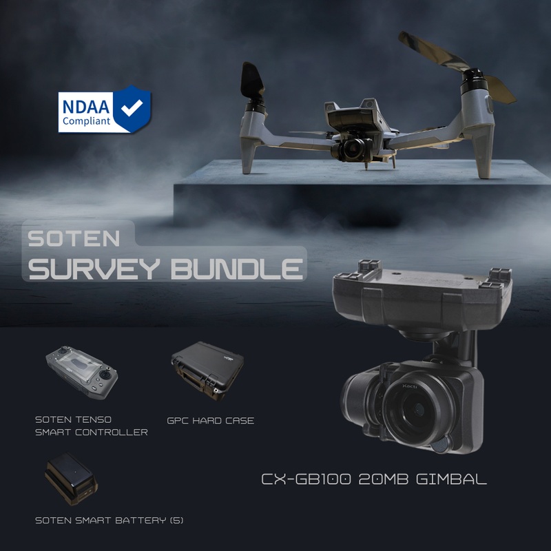
ACSL SOTEN Survey Package – High-Precision Flight, High-Security Control
Built for Professional Survey Operations
The ACSL SOTEN Survey Package delivers an elevated level of control and clarity for professional teams handling mapping, infrastructure assessment, and large-scale fieldwork. Combining the NDAA-compliant SOTEN drone, the ACSL SOTEN Standard Camera, and the rugged TENSO Smart Controller, this package is built for real-world performance in tough conditions.
Complete Aerial Survey Solution
Capture sharp, 20MP images with the Standard Camera’s 1″ RGB sensor and mechanical shutter-perfect for geospatial work and inspection tasks. The TENSO Controller’s bright 1080p display, AES256 encrypted connection, and customizable settings let you adapt flight behavior to every mission. Built to last, it’s rated for 14F-104F operation with up to 3 hours of battery life.
Key Features
Optimized for extended-use, survey-grade performance in remote and regulated environments.
- Includes ACSL SOTEN Standard Camera: 1″ sensor, 20MP, mechanical shutter
- TENSO Smart Controller with reduced latency and real-time exposure controls
- Rugged, IP43-rated controller for tough outdoor deployments
- AES256 encryption ensures secure command and data transmission
- WiFi and LTE connectivity with 2.5-mile range for extended ops
- 5″ full-HD display with 1000 nits brightness for daylight visibility
- Swappable camera support for future sensor upgrades
- FAA Remote ID compliant
- NDAA and ISO15408-certified drone-controller system
- Lightweight foldable drone with 25-minute flight time
Applications
Built for professionals in construction, utilities, public safety, and environmental work.
- Surveying and mapping in remote areas
- Utility and infrastructure inspection
- Construction site documentation and progress updates
- Emergency or disaster response coordination
- Precision land-use planning and analysis
- Environmental field data collection
Why Buy from
partners with surveyors, engineers, and field teams to deploy drone technology that actually works-no guesswork, no delays. We help you integrate the ACSL SOTEN Survey Package into your workflow with expert onboarding, practical setup guidance, and reliable support throughout.
Whether you’re digitizing infrastructure, planning future builds, or monitoring environmental changes, we ensure your system is fully functional and mission-ready from day one. We’re trusted by professionals who need to collect accurate data securely and efficiently-every time.
Equip your team with the ACSL SOTEN Survey Package from and experience professional-grade control with field-proven reliability.
Specifications
- Dimensions: Unfolded: 637mm x 560mm (including propellers), Folded: 162mm x 363mm
- Height: Unfolded 153mm (including propellers)
- Weight: 1,720g (including standard camera and battery)
- Number of rotor blades: 4
- Intelligent battery: Lithium-ion battery 94Wh, 1 pc
- Operating frequency: 2.412 – 2.477 GHz
- Hovering accuracy (using vision positioning): Vertical: 0.1m, Horizontal: 0.3m
- Hovering accuracy (GNSS): Vertical: 0.5m, Horizontal: 1.5m
- Maximum pitch angle: 30
- Maximum angular velocity: Pitch: 80/s, Yaw: 45/s
- Maximum ascent speed: 3m/s
- Maximum descent speed: 2m/s
- Maximum takeoff weight: 2,000g
- Maximum speed (no wind): 15m/s
- Operational limit altitude: 2000m
- Maximum airspeed: 15m/s
- Max flight time: With standard camera, wind speed 8m/s: 25min; Without standard camera, wind speed 8m/s: 29min
- Optional Camera: Infrared camera + visible camera, Multispectral camera, Optical zoom camera
- Ingress protection: IP43 (with camera, gimbal, and battery)
- GNSS: GPS + QZSS + GLONASS + SLAS
- Operating temperature: 0C to 40C
- Optional items: LTE Comms Module, Spare Battery
- Obstacle detection range: Forward: 10m, Up: 5m, Down: 5m
- Obstacle detection angle: 70 horizontal, 40 vertical
- Obstacle detection freq.: Forward: 10Hz, Up: 10Hz, Down: 10Hz
- Operating environment: Adequate lighting and clear texture
- Infrared Sensor – Obstacle detection range: Up: 2m, Down: 12m
- Infrared Sensor – Obstacle detection angle: Up: 27, Down: 2
- Infrared Sensor – Obstacle detection freq.: Up: 50Hz, Down: 50Hz
- Infrared Sensor – Operating environment: Large, diffuse or reflective obstacles
- Remote Controller – Operating frequency: 2.412 to 2.477 GHz
- Remote Controller – Maximum distance: 4km (without obstructions or radio interference)
- Remote Controller – Battery life: Up to 4 hours
- Remote Controller – Operating temperature: 0C to 40C
- Remote Controller – Security: AES encryption method
- Remote Controller – Multiple operations: Control can be transferred between two radio controllers
- Supported Mobile Devices – OS: Android 4.1 or higher
- Supported Mobile Devices – Terminal: USB Type-C
- Supported Mobile Devices – Confirmed models: Sony Xperia 5, 10 III
- Visible Camera – Effective pixels: 20 megapixels
- Visible Camera – Still image shooting method: JPEG / DNG / JPEG+DNG
- Visible Camera – Image quality: Superfine / Fine / Normal; Resolution: 20MP / 15MP / 10MP
- Visible Camera – Video method: MOV / H.264
- Visible Camera – Video quality: 4K: 30fps; 2.7K: 60/30fps; Full HD: 120/60/30fps; HD: 60/30fps; nHD: 240/120/60/30fps
- Visible Camera – Video recording time: 60 min; Auto-split: OFF / 1 / 3 / 5 / 10 min (Split by 4GB in FAT32)
- Visible Camera – Sensor size: 1 inch
- Visible Camera – Shutter system: Mechanical
- Visible Camera – Focus mode: Single AF / Continuous AF / MF; Area: Multi AF / Spot AF
- Visible Camera – Exposure compensation: -2EV to +2EV (step of 1/3EV)
- Visible Camera – Recording media: microSD UHS speed class: U3 or V30; Video class: V30
- Visible Camera – Security: Data encryption can be enabled/disabled
- Camera Gimbal – Mechanism: 3-axis
- Camera Gimbal – Operable range: Pan: 85; Tilt: -115 to 45
- Camera Gimbal – Max speed: Pan: 60/s; Tilt and roll: 100/s
- Camera Gimbal – Control accuracy: 0.02
- Camera Gimbal – Switching method: One-touch camera switching
- Infrared + Visible Camera – Effective pixels: Visible: 12MP; Infrared: 81,920 pixels
- Infrared + Visible Camera – Temperature resolution: <60mK
- Infrared + Visible Camera – Dynamic range: Up to +140C (high gain)
- Infrared + Visible Camera – Image quality: Superfine / Fine / Normal
- Infrared + Visible Camera – Video method: MOV / H.264
- Infrared + Visible Camera – Video quality: Full HD / HD
- Infrared + Visible Camera – Recording time: 60 min; Auto-split: OFF / 1 / 3 / 5 / 10 min (Split by 4GB in FAT32)
- Infrared + Visible Camera – Recording media: microSD UHS speed class: U3 or V30; Video class: V30
- Infrared + Visible Camera – Security: Encrypted data can be recorded; Encryption can be enabled/disabled
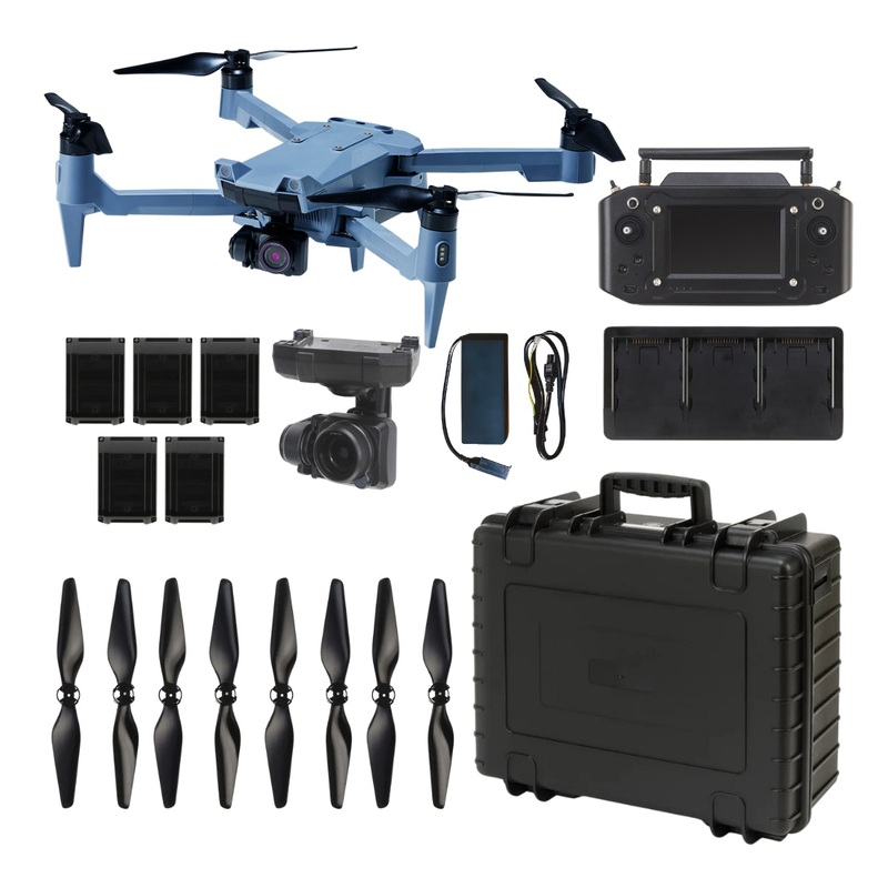
In The Box
- 1x SOTEN Aircraft
- 1x Tenso Smart Controller (NDAA Compliant)
- 1x Battery Charger
- 2x Propeller Set
- 5x Smart Battery
- 1x Standard 20MP Camera
- 1x Hard Case
- 1x Triple Cradle Charger


Reviews
There are no reviews yet.