Welcome to our store!

November 2024: Currently DJI mapping drones have been arriving in very small quantities, Could take 3-4 weeks to fufil your order. If you would like to put a deposit to put your name on the list, please email [email protected] the years we continue working wit
November 2024: Currently DJI mapping drones have been arriving in very small quantities, Could take 3-4 weeks to fufil your order. If you would like to put a deposit to put your name on the list, please email [email protected]
Over the years we continue working with farmers and other industry professionalsto provide the best “ready to fly” kits. This new drone surveying for farmers system is without a doubt thelatest and greatest!!!
What’s in the box:
We also highly recommendreadingthe owners manual and viewing the website www.knowbeforeyoufly.org before your first flight.
Newly upgraded imaging system with one 20MP RGB camera and four 5MP multispectral cameras (green, red, red edge, and near-infrared). Enables applications for our agricultural drone kits such as high-precision aerial surveying, crop growth monitoring, and natural resource surveys.
Near-infrared (NIR) 860 nm 26 nm
Red edge (RE) 730 nm 16 nm
Red (R) 650 nm 16 nm
Green (G) 560 nm 16 nm
4/3 CMOS – 20MP Image Sensor
1/2000s – Fastest mechnaical shutter speed
0/7s – High speed burst when RGB camera is used
The built-in sunlight sensor on this surveying drone for farmers captures solar irradiance and records it in an image file, allowing for light compensation of image data during 2D reconstruction. This results in more accurate NDVI results, as well as improved accuracy and consistency of data acquired over.
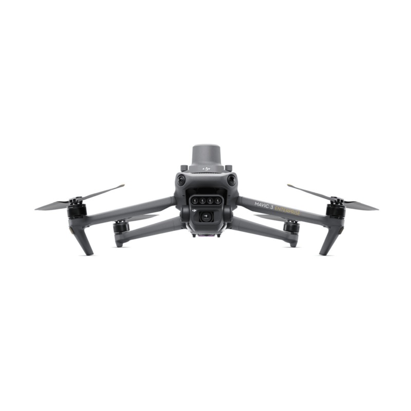
DJI Mavic 3M with RTK module for centimeter-level positioning. Flight control, the camera, and the RTK module sync in microseconds to accurately capture the location of each camera’s imaging center. This enables DJI Mavic 3M to do high-precision aerial drone surveying without using ground control points.
43 minutes Cruise Time
200 hectare – A single flight can complete mapping operations over an area of 200 hectares.
100W Battery Charging Hub | High-efficiency fast charging
88W fast charging | Aircraft
The O3 transmission integrates two transmitting signals and four receiving signals to support 15km ultra-long transmission distances.
This agricultural drone kit features multiple wide-FOV vision sensors that accurately detect obstacles in all directions for omnidirectional obstacle avoidance. The terrain-follow aerial surveying can be easily performed in steep-slope landscapes.
Mavic 3M allows terrain-follow aerial surveying of orchards, even on sloped landscapes. Together with DJI Terra or DJI SmartFarm Platform to reconstruct high-resolution orchard maps, automatically identify the number of trees, distinguish trees from other obstacles or objects, and generate three-dimensional operation routes for agricultural drones, making operations safer and more efficient.The DJI Mavic 3M agricultural drone makes drone surveying for farmers a breeze.
For rice fertilization, cotton growth regulation, and potato foliar fertilizer spraying, the Mavic 3M is used to obtain multi-spectral images of crops. DJI Terra or the DJI SmartFarm Platform can then generate NDVI and other vegetation indices maps, capturing differences in crop potential and generating prescription maps that allow agricultural drones to execute variable-rate application. This ultimately allows users to reduce costs, increase yield, and protect the environment.
The Mavic 3M can carry out automatic field scouting. The field scout images from this agricultural drone kit can be uploaded to the DJI SmartFarm Platform in real time through a 4G network. It can find abnormalities, such as emergence deficiencies, weed pressure, and crop lodging in a timely manner. It can also conduct intelligent analyses, such as cotton seedling identification and rice production testing, using AI identification for real-time sharing of crop growth information, guidance of agronomic activities, and easy management of 70 hectares of farmland by one person.
DJI is driven by the relentless pursuit of making complex technology accessible to all. Nowhere is this commitment more visible than in how they help commercial, civil, and government users around the world to find innovative ways to use their technology, bringing value throughout a wide range of industries. Given the unique role drones play as a data capture device, DJI understands how important data security is to commercial, civil and government customers. Thats why DJI gives users control over the data they generate. They buttress this commitment by providing in-depth information on how DJI drone platforms protect the data of customers, and outlining the strategies and processes they use to continually improve information security.You Control Your Data
DJI will not access any user data unless the user grants DJI permission to do so. Users can choose to grant or revoke permissions anytime in the “Network Security Mode” settings. Such permissions include access to device information, flight records, device logs, approximate location information, user experience improvement program information, and whether DJI can share your device location with third-party map service providers in order to display your location on the map. You can enable “Local Data Mode” to use your device completely offline. In this case, you do not need to log in to your DJI account. Installer packages to upgrade your device can be downloaded directly from the DJI website. Soon, we will release features such as custom offline maps and offline import of certificates to unlock restricted zones.Data Encrypted for Enhanced Security
Data transmitted between the drone and the controller on the ground is protected by the AES-256 encryption algorithm. The communication between the DJI Pilot app and the server is also protected by HTTPS or WebSockets over SSL/TLS (WSS) protocol to prevent hijacking by third parties.Secure Device Media Storage
DJI Mavic 3 Enterprise drones support a password protection mechanism for onboard data storage to guarantee the security of sensitive images and resources. When the password function is enabled, data stored in the SD card or onboard storage can be accessed only after the user-defined password is provided. The user-defined password is not shared with DJI, which means DJI cannot retrieve this password if you forget it.
Reviews
There are no reviews yet.